Sary:Tunis Gulf topo map-fr.svg

Taille de cet aperçu PNG pour ce fichier SVG : 663 × 600 teboka. Habe hafa: 265 × 240 teboka | 531 × 480 teboka | 849 × 768 teboka | 1 132 × 1 024 teboka | 2 264 × 2 048 teboka | 1 990 × 1 800 teboka
Rakitra niaviana (rakitra SVG, habe 1 990 × 1 800 teboka, habe : 2,58 Mio)
Ambangovangony
| Lieu de la prise de vue | | Voir cet endroit et d’autres images sur : OpenStreetMap |
|---|
| Visavisa |
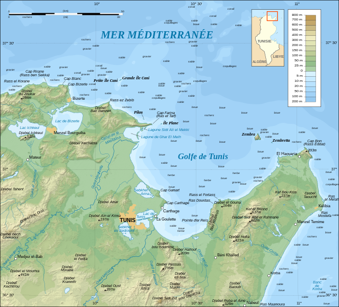
English: Topographic and bathymetric map in French of the Gulf of Tunis, Tunisia, with indication of the nature of the sea bottom.
Note: The shaded relief is a raster image embedded in the SVG file. Français : Carte topographique et bathymétrique en français du Golfe de Tunis, avec indication de la nature des fonds marins.
Note : Les ombres du relief sont une image bitmap embarquée dans le fichier SVG. UTM projection ; WGS84 datum ; shaded relief (composite image of N-W, W and N lightning positions) ; |
||
| Daty | |||
| Loharano |
Own work ;
|
||
| Mpamorona azy | Eric Gaba (Sting - fr:Sting) | ||
| Alalana (Hampiasa ity rakitra ity indray) |
|
||
| Versiona hafa |
[]
|


|
Ce fichier SVG contient du texte encapsulé pouvant facilement être traduit dans votre langue en utilisant n'importe quel éditeur de fichier SVG ou de texte, ou par l'outil de traduction de fichiers SVG. Pour plus d'informations, voir : A propos de la traduction des fichiers SVG. |
Moi, en tant que détenteur des droits d’auteur sur cette œuvre, je la publie sous les licences suivantes :

|
Nomena ny alalana mandika, mizara ary/na manova ity rakitra ity araka ny GNU Free Documentation License na versiona hafa toariana natontan'i Free Software Foundation; tsy misy fizarana tsy azo ovaina, tsy misy soratra andoham-pejy na soratra am-param-pejy. Ao amin'ny fizarana mitondra anarana GNU Free Documentation License ny soratr'ity fahazoan-dalana ity. |
Ce fichier est sous licence Creative Commons Attribution – Partage dans les Mêmes Conditions 3.0 (non transposée), 2.5 Générique, 2.0 Générique et 1.0 Générique.
- Azonao am-palalahana:
- ny mizara – ny mandika, mizara sy manome ity vokatr'asa ity
- ny mamerina – ny manova ity vokatr'asa ity
- Raha manaraka ireo fepetra ireo :
- mahalala ny namorona azy voalohany – Tsy maintsy manome fampahalalana arifomba momba ny mpamorona ianao, manome rohy manondro ny fahazoan'alalana ary raha nisy fiovana natao. Azonao atao amin'izay fomba rehetra azo atao izany zavatra izany, fa tsy amin'ny fomba milaza hoe manohana na manaiky ny fampiasanao an'ilay asa ilay mpamorona.
- zaraina mitovy – Raha manova, mamadika na mifototra amin'ity asa ity ianao dia tsy maintsy mizara ny vokany amin'ny lisansa mitovy na mifandraika amin'ny lisansan'ny asa niaviana.
Afaka mifidy iray amin'ireo lisansa ireo ianao.
Tantara ny rakitra
Tsindrio eo amin'ny daty/ora iray mba hijery ny toetra n'ilay rakitra tamin'io fotoana io.
| Daty sy ora | saritapaka | Habe | Mpikambana | resaka | |
|---|---|---|---|---|---|
| ankehitriny | 1 Septambra 2008 à 00:31 | | 1 990 × 1 800 (2,58 Mio) | Sting | New standard colors |
| 25 Oktobra 2007 à 22:16 |  | 1 990 × 1 800 (2,57 Mio) | Sting | Zembra / Zembretta islands correction ; + nature of the sea bottom indications | |
| 25 Oktobra 2007 à 20:42 |  | 1 990 × 1 800 (2,52 Mio) | Sting | {{Information |Description=Topographic map in French of the Gulf of Tunis, Tunisia |Source=Own work ;<br/>Topographic map : [http://www2.jpl.nasa.gov/srtm NASA Shuttle Radar Topography Mission] (SRTM3 v.2) (public domain) edited with |
Fampiasana an'io rakitra io
Mampiasa ity rakitra ity io pejy io:
Fampiasan-drakitra maneran-tontolo
Mampiasa ity rakitra ity ireo wiki hafa ireo:
- Fampiasana eo amin'i de.wikipedia.org
- Fampiasana eo amin'i en.wikipedia.org
- Fampiasana eo amin'i es.wikipedia.org
- Fampiasana eo amin'i fr.wikipedia.org
- Province d'Afrique
- Utilisateur:Pline/création article
- Liste des golfes de Tunisie
- Golfe de Tunis
- Utilisateur:Urban/cartes
- Site archéologique de Carthage
- Utilisateur:Pradigue/Byrsa
- Église du prêtre Félix et baptistère de Kélibia
- Wikipédia:Atelier graphique/Cartes/Archives/Demandes mises en sommeil/Monde
- Discussion utilisateur:Sting/Archive 17
- Phare de Sidi Bou Saïd
- Phare de Zembretta
- Phare du Cap Bon
- Fampiasana eo amin'i fy.wikipedia.org
- Fampiasana eo amin'i he.wikipedia.org
- Fampiasana eo amin'i hr.wikipedia.org
- Fampiasana eo amin'i id.wikipedia.org
- Fampiasana eo amin'i ja.wikipedia.org
- Fampiasana eo amin'i ko.wikipedia.org
- Fampiasana eo amin'i lt.wikipedia.org
- Fampiasana eo amin'i nl.wikipedia.org
- Fampiasana eo amin'i no.wikipedia.org
- Fampiasana eo amin'i oc.wikipedia.org
- Fampiasana eo amin'i pl.wikipedia.org
- Fampiasana eo amin'i pl.wiktionary.org
- Fampiasana eo amin'i pt.wikipedia.org
- Fampiasana eo amin'i sl.wikipedia.org
- Fampiasana eo amin'i sv.wikipedia.org
- Fampiasana eo amin'i zh.wikipedia.org