Sary:Tibet provinces.png
Haben'ny topi-maso: 800 × 555 teboka. Habe hafa: 320 × 222 teboka | 640 × 444 teboka | 1 024 × 711 teboka | 1 421 × 986 teboka
Rakitra niaviana (1 421 × 986 teboka, haben'ilay rakitra : 871 kio, endrika MIME : image/png)
| Visavisa |
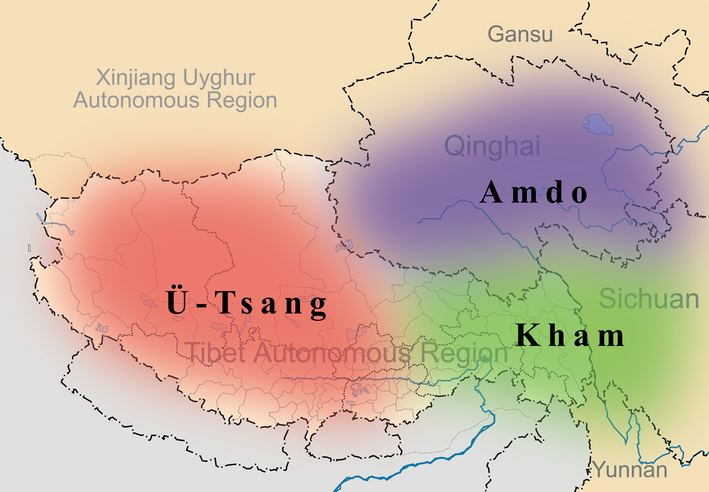
English: A simple map of the three traditional provinces of Tibet overlaid on a map of modern provincial boundaries of the People's Republic of China. |
| Daty | (UTC) |
| Loharano | |
| Mpamorona azy |
|
| Cette image a été retouchée, ce qui signifie qu'elle a été modifiée par ordinateur et est différente de l'image d'origine. Liste des modifications : added traditional provinces overlay. L'image d'origine se trouve ici : Map of Tibet Ü-Tsang Amdo and Kham.jpg:
|
Ity rakita ity dia mitondra ny fahazoan-dalana Creative Commons Attribution-Share Alike 3.0 Unported
- Azonao am-palalahana:
- ny mizara – ny mandika, mizara sy manome ity vokatr'asa ity
- ny mamerina – ny manova ity vokatr'asa ity
- Raha manaraka ireo fepetra ireo :
- mahalala ny namorona azy voalohany – Tsy maintsy manome fampahalalana arifomba momba ny mpamorona ianao, manome rohy manondro ny fahazoan'alalana ary raha nisy fiovana natao. Azonao atao amin'izay fomba rehetra azo atao izany zavatra izany, fa tsy amin'ny fomba milaza hoe manohana na manaiky ny fampiasanao an'ilay asa ilay mpamorona.
- zaraina mitovy – Raha manova, mamadika na mifototra amin'ity asa ity ianao dia tsy maintsy mizara ny vokany amin'ny lisansa mitovy na mifandraika amin'ny lisansan'ny asa niaviana.
Laogin'ny fampidirana loharano
This image is a derivative work of the following images:
- File:Tibet&neighbors_Locator_map.svg licensed with Cc-by-sa-3.0, GFDL
- 2009-10-13T22:22:54Z Keithonearth 1520x1059 (188220 Bytes) {{Information |Description={{en|1=A simple map of the Tibetan Autonomous Region, and surrounding Nations, and States. It was made for [[:en:Template:Location map China Tibet]].}} |Source={{own}} |Author=[[User:Keithonearth|K
- File:Map_of_Tibet_Ü-Tsang_Amdo_and_Kham.jpg licensed with Cc-by-sa-2.5
Téléversé avec derivativeFX
Tantara ny rakitra
Tsindrio eo amin'ny daty/ora iray mba hijery ny toetra n'ilay rakitra tamin'io fotoana io.
| Daty sy ora | saritapaka | Habe | Mpikambana | resaka | |
|---|---|---|---|---|---|
| ankehitriny | 27 Martsa 2011 à 21:35 | | 1 421 × 986 (871 kio) | Kmusser | {{Information |Description={{en|1=A simple map of the three traditional provinces of Tibet overlaid on a map of modern provincial boundaries of the People's Republic of China.}} == |Source=*File:Tibet&neighbors_Locator_map.svg *[[:File:Map_of_Tibet_ |
Fampiasana an'io rakitra io
Mampiasa ity rakitra ity io pejy io:
Fampiasan-drakitra maneran-tontolo
Mampiasa ity rakitra ity ireo wiki hafa ireo:
- Fampiasana eo amin'i ast.wikipedia.org
- Fampiasana eo amin'i bg.wikipedia.org
- Fampiasana eo amin'i bn.wikipedia.org
- Fampiasana eo amin'i cdo.wikipedia.org
- Fampiasana eo amin'i cs.wikipedia.org
- Fampiasana eo amin'i da.wikipedia.org
- Fampiasana eo amin'i de.wikipedia.org
- Fampiasana eo amin'i diq.wikipedia.org
- Fampiasana eo amin'i en.wikipedia.org
- Fampiasana eo amin'i en.wikivoyage.org
- Fampiasana eo amin'i en.wiktionary.org
- Fampiasana eo amin'i eo.wikipedia.org
- Fampiasana eo amin'i es.wikipedia.org
- Fampiasana eo amin'i et.wikipedia.org
- Fampiasana eo amin'i eu.wikipedia.org
- Fampiasana eo amin'i fa.wikipedia.org
- Fampiasana eo amin'i fr.wikipedia.org
- Fampiasana eo amin'i fr.wiktionary.org
- Fampiasana eo amin'i ga.wikipedia.org
- Fampiasana eo amin'i hi.wikipedia.org
- Fampiasana eo amin'i hu.wikipedia.org
Hijery fampiasana eran-terikasan'ity rakitra ity.