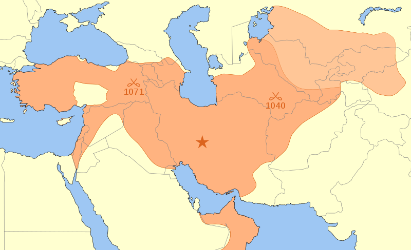
Sary:Seljuk Empire locator map.svg

Taille de cet aperçu PNG pour ce fichier SVG : 800 × 488 teboka. Habe hafa: 320 × 195 teboka | 640 × 390 teboka | 1 024 × 625 teboka | 1 280 × 781 teboka | 2 560 × 1 562 teboka
Rakitra niaviana (rakitra SVG, habe 800 × 488 teboka, habe : 161 kio)
Tantara ny rakitra
Tsindrio eo amin'ny daty/ora iray mba hijery ny toetra n'ilay rakitra tamin'io fotoana io.
| Daty sy ora | saritapaka | Habe | Mpikambana | resaka | |
|---|---|---|---|---|---|
| ankehitriny | 5 Jiona 2014 à 13:24 |  | 800 × 488 (161 kio) | Ras67 | frame removed |
| 30 Aogositra 2009 à 21:28 |  | 642 × 396 (204 kio) | Dipa 1965 | Neither Aegean islands nor Cyprus belonged to Seljuk territory | |
| 12 Martsa 2008 à 04:26 |  | 642 × 396 (201 kio) | MapMaster | + two battle locations | |
| 11 Martsa 2008 à 02:32 |  | 642 × 396 (197 kio) | MapMaster | an attempt to fix problem w/gallery | |
| 11 Martsa 2008 à 01:57 |  | 642 × 393 (197 kio) | MapMaster | Removed BMP artifact | |
| 11 Martsa 2008 à 01:49 |  | 642 × 393 (198 kio) | MapMaster | {{Information |Description=A map showing the w:en:Great Seljuk Empire\Great Seljuk Empire at its height, upon the death of w:en:Malik Shah in 1092. |Source=self-made |Date=10 March 2008 |Author= MapMaster |Permission= |other_ver |
Fampiasana an'io rakitra io
Mampiasa ity rakitra ity ireo pejy 2 ireo:
Fampiasan-drakitra maneran-tontolo
Mampiasa ity rakitra ity ireo wiki hafa ireo:
- Fampiasana eo amin'i af.wikipedia.org
- Fampiasana eo amin'i als.wikipedia.org
- Fampiasana eo amin'i ar.wikipedia.org
- الدولة السلجوقية
- غوريون
- سلاجقة العراق
- فخر الدين الرازي
- الإسلام في تركستان الشرقية
- تاريخ إيران
- جلال الدولة ملك شاه
- بوابة:الإمبراطورية الروسية
- بوابة:الإمبراطورية الروسية/بوابات شقيقة
- النزاعات في آسيا
- بوابة:الإمبراطورية الألمانية
- بوابة:الإمبراطورية الألمانية/بوابات شقيقة
- بوابة:إمبراطورية اليابان
- بوابة:إمبراطورية اليابان/بوابات شقيقة
- بوابة:الخلافة الراشدة
- بوابة:الدولة الأموية
- الحروب السلجوقية البيزنطية
- بوابة:الإمبراطورية الفرنسية الأولى/بوابات شقيقة
- بوابة:الإمبراطورية الفرنسية الأولى
- بوابة:الإمبراطورية النمساوية/بوابات شقيقة
- بوابة:الإمبراطورية النمساوية
- بوابة:الإمبراطورية البريطانية
- بوابة:الإمبراطورية البريطانية/بوابات شقيقة
- بوابة:الإمبراطورية الفرنسية الثانية
- بوابة:الإمبراطورية الفرنسية الثانية/بوابات شقيقة
- بوابة:الإمبراطورية البرتغالية
- بوابة:الإمبراطورية البرتغالية/بوابات شقيقة
- بوابة:الإمبراطورية النمساوية المجرية
- بوابة:الإمبراطورية النمساوية المجرية/بوابات شقيقة
- بوابة:الإمبراطورية المغولية
- بوابة:الإمبراطورية المغولية/بوابات شقيقة
- بوابة:الإمبراطورية الإسبانية
- بوابة:إمبراطوريات
- بوابة:إمبراطوريات/بوابات شقيقة
- بوابة:الإمبراطورية الإسبانية/بوابات شقيقة
- بوابة:العصور الوسطى/مقالة مختارة
- بوابة:العصور الوسطى/مقالة مختارة/15
- بوابة:الدولة الأموية/بوابات شقيقة
- بوابة:الخلافة الراشدة/بوابات شقيقة
- بوابة:مملكة فرنسا
- بوابة:مملكة فرنسا/بوابات شقيقة
- بوابة:الإمبراطورية الرومانية المقدسة
- بوابة:الإمبراطورية الرومانية المقدسة/بوابات شقيقة
- قالب:بوابات الإمبراطوريات
- طغان شاه
- أرسلان أرغون
- أرسلان شاه (سلاجقة العراق)
- مؤيد الملك
Hijery fampiasana eran-terikasan'ity rakitra ity.

