Sary:Second Severn Crossing pano 1.jpg
Haben'ny topi-maso: 798 × 138 teboka. Habe hafa: 320 × 55 teboka | 640 × 111 teboka | 1 024 × 177 teboka | 1 280 × 221 teboka | 6 880 × 1 190 teboka
Rakitra niaviana (6 880 × 1 190 teboka, haben'ilay rakitra : 1,77 Mio, endrika MIME : image/jpeg)
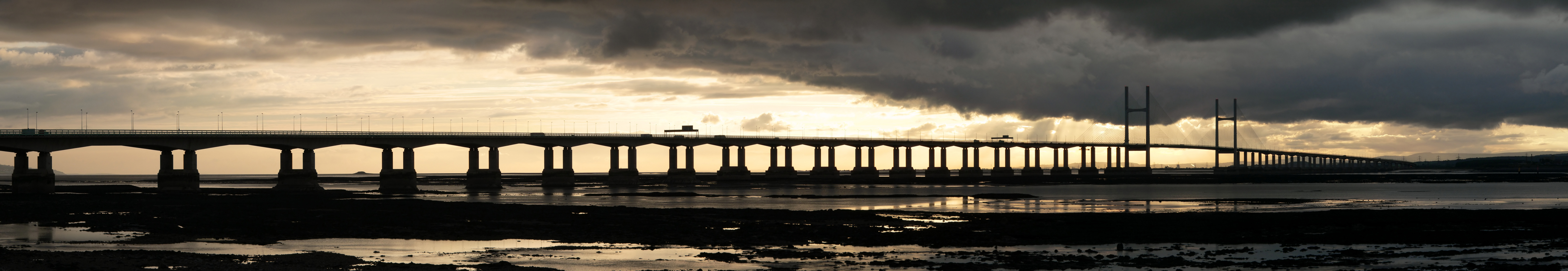
This image was selected as picture of the day on Wikimedia Commons for 30 October 2009. It was captioned as follows: English: The Second Severn Crossing carrying the M4 motorway across the River Severn between Severn Beach near Avonmouth in south west England and Caldicot in south Wales. Other languages:
Bahasa Indonesia: Second Severn Crossing (Jembatan Severn Kedua) yang dilintasi jalan raya M4 melalui Sungai Severn antara Pantai Severn di dekat Avonmouth di barat daya Inggris dan Caldicot di selatan Wales. Bosanski: „Second Severn Crossing“ nosi autoput „M-4“ preko rijeke Severn između Severn Beach-a pored Avonmouth-a u jugozapadnoj Engleskoj i Caldicot-a u južnom Velsu. Čeština: Most Second Severn Crossing, po kterém britská dálnice M4 překonává řeku Severn mezi anglickým Avonmouthem a velšským Caldicotem Dansk: Motorvejsbroen, som fører M4-motorvejen over floden Severn mellem Severn Beach nær Avonmouth i det sydvestlige England og Caldicot i det sydlige Wales. English: The Second Severn Crossing carrying the M4 motorway across the River Severn between Severn Beach near Avonmouth in south west England and Caldicot in south Wales. Español: Segundo puente sobre el río Severn, por el que transcurre la autovía M4 entre Severn Beach (Inglaterra) y Caldicot (País de Gales). Français : Le Second pont sur la rivière Severn, portant l'autoroute M4 entre Severn Beach (Angleterre) et Caldicot (Pays de Galles), vu du coté anglais. Italiano: Il ponte autostradale sul Severn, che collega Severn Beach (in Inghilterra) a Caldicot (in Galles), visto dalla sponda inglese. Magyar: Az angliai Severn-folyót átszelő M4-es autópálya hídja (Avonmouth, délnyugat Anglia és Caldicot, dél Wales között) Nederlands: De Second Severn Crossing, een brug die de Britse autosnelweg M4 over de Severn (de langste rivier van het Verenigd Koninkrijk) draagt, tussen het Engelse dorp Severn Beach (nabij Bristol) en het Welshe stadje Caldicot. Português: Segunda Ponte do Severn (substituta da antiga Ponte do Severn) que cruza o Rio Severn no Reino Unido. Македонски: Вториот премин на реката Северн со автопатот M4 помеѓу југозападна Англија и јужен Велс. বাংলা : সেভেন সেভার্ন ক্রসিংয়ের ওপর অবস্থিত এম৪ সড়কপথ। সেভার্ন নদীর দুই প্রান্ত; পশ্চিম ইংল্যান্ডের অ্যাভনমাউথ ও দক্ষিণ ওয়েলসের ক্যালডিকট অঞ্চলকে যুক্ত করে এর অবস্থান। |
Ambangovangony
| Visavisa |
English: The Second Severn Crossing carrying the M4 motorway across the River Severn between Severn Beach near Avonmouth in south west England and Caldicot in south Wales. This view, composed from 16 separate images, is looking west from the English side. The bridge has a total span of 5.1 km and includes a cable-stayed section called the Shoots Bridge which spans the shipping channel between the two towers. The River Severn has a vast tidal range - the point from which this photograph was taken would be covered at high tide.
Français : Le Second pont sur la rivière Severn, portant l'autoroute M4 entre Severn Beach (Angleterre) et Caldicot (Pays de Galles), vu du coté anglais. Le pont a une portée totale de 5,1 km et possède une section nommée Shoots Bridge par dessus le chenal navigable. La rivière Severn à une très forte marée. Le point d'où la photo a été prise est couvert par les hautes eaux. Cette vue panoramique est constituée à partir de 16 images séparées. |
| Daty | |
| Loharano | Asan'ny tena |
| Mpamorona azy | Yummifruitbat |
| Alalana (Hampiasa ity rakitra ity indray) |
CC-BY-SA 2.5 |
| Versiona hafa | Derivative works of this file: Severn Crossing banner.jpg |
| Lieu de la prise de vue | | Voir cet endroit et d’autres images sur : OpenStreetMap |
|---|
|

Moi, en tant que détenteur des droits d’auteur sur cette œuvre, je la publie sous la licence suivante :
Ce fichier est disponible selon les termes de la licence Creative Commons Attribution – Partage dans les Mêmes Conditions 2.5 Générique
- Azonao am-palalahana:
- ny mizara – ny mandika, mizara sy manome ity vokatr'asa ity
- ny mamerina – ny manova ity vokatr'asa ity
- Raha manaraka ireo fepetra ireo :
- mahalala ny namorona azy voalohany – Tsy maintsy manome fampahalalana arifomba momba ny mpamorona ianao, manome rohy manondro ny fahazoan'alalana ary raha nisy fiovana natao. Azonao atao amin'izay fomba rehetra azo atao izany zavatra izany, fa tsy amin'ny fomba milaza hoe manohana na manaiky ny fampiasanao an'ilay asa ilay mpamorona.
- zaraina mitovy – Raha manova, mamadika na mifototra amin'ity asa ity ianao dia tsy maintsy mizara ny vokany amin'ny lisansa mitovy na mifandraika amin'ny lisansan'ny asa niaviana.
Tantara ny rakitra
Tsindrio eo amin'ny daty/ora iray mba hijery ny toetra n'ilay rakitra tamin'io fotoana io.
| Daty sy ora | saritapaka | Habe | Mpikambana | resaka | |
|---|---|---|---|---|---|
| ankehitriny | 14 Septambra 2006 à 22:40 | 6 880 × 1 190 (1,77 Mio) | Yummifruitbat | {{Information |Description=The Second Severn Crossing carrying the M4 motorway across the River Severn between Severn Beach near Avonmouth in south west [ |
Fampiasana an'io rakitra io
Mampiasa ity rakitra ity ireo pejy 2 ireo:
Fampiasan-drakitra maneran-tontolo
Mampiasa ity rakitra ity ireo wiki hafa ireo:
- Fampiasana eo amin'i bn.wikipedia.org
- Fampiasana eo amin'i crh.wikipedia.org
- Fampiasana eo amin'i cv.wikipedia.org
- Fampiasana eo amin'i da.wikipedia.org
- Fampiasana eo amin'i de.wikipedia.org
- Fampiasana eo amin'i en.wikipedia.org
- Fampiasana eo amin'i en.wikibooks.org
- Fampiasana eo amin'i fr.wikipedia.org
- Fampiasana eo amin'i hu.wikipedia.org
- Fampiasana eo amin'i id.wikipedia.org
- Fampiasana eo amin'i ko.wikipedia.org
- Fampiasana eo amin'i krc.wikipedia.org
- Fampiasana eo amin'i lbe.wikipedia.org
- Fampiasana eo amin'i mk.wikipedia.org
- Fampiasana eo amin'i no.wikipedia.org
- Fampiasana eo amin'i os.wikipedia.org
- Fampiasana eo amin'i pam.wikipedia.org
- Fampiasana eo amin'i pl.wikipedia.org
- Fampiasana eo amin'i pt.wikipedia.org
- Fampiasana eo amin'i ru.wikipedia.org
- Fampiasana eo amin'i ru.wikinews.org
- Fampiasana eo amin'i sah.wikipedia.org
- Fampiasana eo amin'i uk.wikipedia.org
- Fampiasana eo amin'i vi.wikipedia.org
- Fampiasana eo amin'i xal.wikipedia.org
- Fampiasana eo amin'i zh.wikipedia.org