Sary:Maricopa County Incorporated and Planning areas Chandler highlighted.svg

Taille de cet aperçu PNG pour ce fichier SVG : 694 × 599 teboka. Habe hafa: 278 × 240 teboka | 556 × 480 teboka | 889 × 768 teboka | 1 185 × 1 024 teboka | 2 371 × 2 048 teboka | 940 × 812 teboka
Rakitra niaviana (rakitra SVG, habe 940 × 812 teboka, habe : 1,05 Mio)
Ambangovangony
| Visavisa |
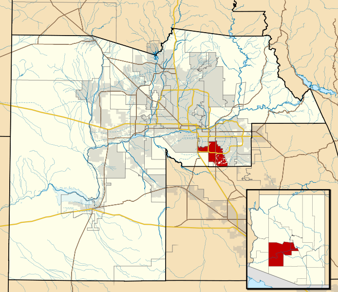
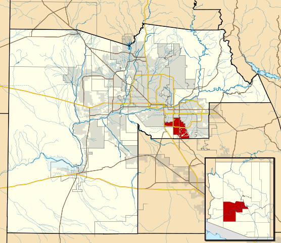
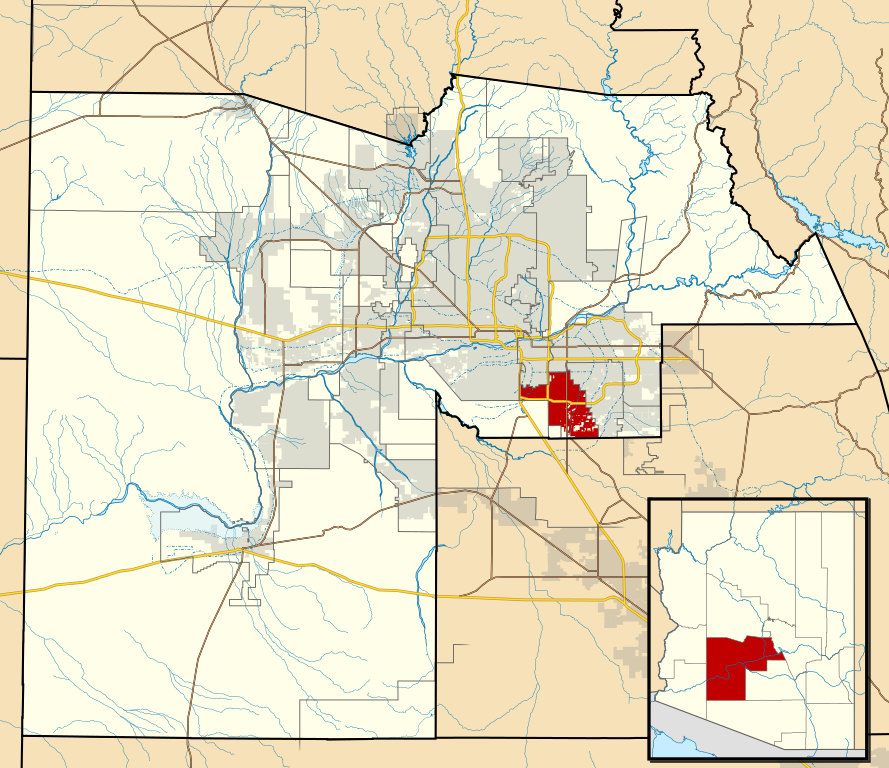
This map shows the incorporated areas and Indian reservation boundaries in Maricopa County, Arizona, along with water bodies and major highways and roads.
|
| Daty | |
| Loharano | My own work, based on government information |
| Mpamorona azy | Ixnayonthetimmay |
| Alalana (Hampiasa ity rakitra ity indray) |
Public Domain |
| Versiona hafa | See Category:Maps of Maricopa County for other versions of this image. |
| Moi, propriétaire des droits d’auteur sur cette œuvre, la place dans le domaine public. Ceci s'applique dans le monde entier. Dans certains pays, ceci peut ne pas être possible ; dans ce cas : J’accorde à toute personne le droit d’utiliser cette œuvre dans n’importe quel but, sans aucune condition, sauf celles requises par la loi. |
Tantara ny rakitra
Tsindrio eo amin'ny daty/ora iray mba hijery ny toetra n'ilay rakitra tamin'io fotoana io.
| Daty sy ora | saritapaka | Habe | Mpikambana | resaka | |
|---|---|---|---|---|---|
| ankehitriny | 20 Mey 2011 à 06:15 | | 940 × 812 (1,05 Mio) | Ixnayonthetimmay | Uploading new version |
| 30 Aogositra 2008 à 04:01 |  | 900 × 800 (413 kio) | Ixnayonthetimmay | == Summary == {{Information |Description=This map shows the incorporated areas and unincorporated areas in Maricopa County, Arizona. [[:en:Chandler, Arizona| | |
| 15 Septambra 2007 à 23:57 |  | 900 × 800 (384 kio) | Ixnayonthetimmay | ||
| 15 Septambra 2007 à 23:56 |  | 900 × 800 (384 kio) | Ixnayonthetimmay | == Summary == {{Information |Description=This map shows the incorporated areas in Maricopa County, Arizona. It also shows the boundaries for the municipal planning areas. The [[:en:Fort | |
| 28 Mey 2007 à 09:52 |  | 900 × 780 (329 kio) | Ixnayonthetimmay | ||
| 21 Mey 2007 à 23:54 |  | 900 × 780 (318 kio) | Ixnayonthetimmay | ||
| 30 Janoary 2007 à 04:55 |  | 904 × 758 (177 kio) | Ixnayonthetimmay | {{Information |Description=This map shows the incorporated areas in Maricopa County, Arizona, highlighting Chandler in red. It also shows the boundaries for the |
Fampiasana an'io rakitra io
Mampiasa ity rakitra ity io pejy io:
Fampiasan-drakitra maneran-tontolo
Mampiasa ity rakitra ity ireo wiki hafa ireo:
- Fampiasana eo amin'i ar.wikipedia.org
- Fampiasana eo amin'i arz.wikipedia.org
- Fampiasana eo amin'i br.wikipedia.org
- Fampiasana eo amin'i ca.wikipedia.org
- Fampiasana eo amin'i ceb.wikipedia.org
- Fampiasana eo amin'i de.wikipedia.org
- Fampiasana eo amin'i el.wikipedia.org
- Fampiasana eo amin'i eo.wikipedia.org
- Fampiasana eo amin'i es.wikipedia.org
- Fampiasana eo amin'i eu.wikipedia.org
- Fampiasana eo amin'i fi.wikipedia.org
- Fampiasana eo amin'i fr.wikipedia.org
- Fampiasana eo amin'i ga.wikipedia.org
- Fampiasana eo amin'i ht.wikipedia.org
- Fampiasana eo amin'i hu.wikipedia.org
- Fampiasana eo amin'i id.wikipedia.org
- Fampiasana eo amin'i it.wikipedia.org
- Fampiasana eo amin'i ja.wikipedia.org
- Fampiasana eo amin'i kw.wikipedia.org
- Fampiasana eo amin'i pl.wikipedia.org
- Fampiasana eo amin'i pt.wikipedia.org
- Fampiasana eo amin'i ro.wikipedia.org
- Fampiasana eo amin'i sr.wikipedia.org
- Fampiasana eo amin'i sv.wikipedia.org
- Fampiasana eo amin'i sw.wikipedia.org
- Fampiasana eo amin'i tt.wikipedia.org
- Fampiasana eo amin'i ur.wikipedia.org
- Fampiasana eo amin'i vi.wikipedia.org
- Fampiasana eo amin'i vo.wikipedia.org
- Fampiasana eo amin'i www.wikidata.org
- Fampiasana eo amin'i zh.wikipedia.org