Sary:First century Iudaea province.gif
Rakitra niaviana(575 × 792 teboka, haben'ilay rakitra : 31 kio, endrika MIME : image/gif)

Avy amin'i Wikimedia Commons io rakitra io ary mety ampiasain'ny tetikasa hafa. Aseho eo ambany ny famisavisana ilay rakitra.

Cette image (de type carte) devrait être recréée dans un format vectoriel, en tant que fichier SVG. Cela offrirait plusieurs avantages : voir Commons:Media for cleanup pour plus d'informations. Si une version SVG de cette image est déjà disponible, merci de bien vouloir l'envoyer. Après cela, remplacez ce modèle par {{vector version available|nouveau nom d'image.svg}}.

Ambangovangony

Visavisa
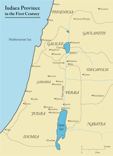
English: This is a map of first century Iudaea Province that I created using Illustrator CS2. I traced this image for the general geographic features. I then manually input data from maps found in a couple of sources.
  • Robert W. Funk and the Jesus Seminar. The Acts of Jesus. HarperSanFrancisco: 1998. p. xxiv.
  • Michael Grant. Jesus: An Historian's Review of the Gospels. Charles Scribner's Sons: 1977. p. 65-67.
  • John P. Meier. A Marginal Jew. Doubleday: 1991. p. 1:434.
Daty 23 Martsa 2006 (date de téléversement originale)
Loharano Transferred from en.wikipedia to Commons.
Mpamorona azy Andrew c sur Wikipedia Anglisy
Alalana
(Hampiasa ity rakitra ity indray)
Released under the GNU Free Documentation License or CC-BY.
Versiona hafa العربيَّة

Navoaka tambanin'ny lisansy

Andrew c de en.wikipedia.org, en tant que détenteur des droits d’auteur sur cette œuvre, la publie sous la licence suivante :
GNU head Nomena ny alalana mandika, mizara ary/na manova ity rakitra ity araka ny GNU Free Documentation License na versiona hafa toariana natontan'i Free Software Foundation; tsy misy fizarana tsy azo ovaina, tsy misy soratra andoham-pejy na soratra am-param-pejy. Ao amin'ny fizarana mitondra anarana GNU Free Documentation License ny soratr'ity fahazoan-dalana ity. Sujet aux avertissements.
w:fr:Creative Commons
mahalala ny namorona azy voalohany
Ce fichier est disponible selon les termes de la licence Creative Commons Attribution 3.0 Non transposée.
Fampatsiahivana: Wikipedia User:Andrew c
Azonao am-palalahana:
  • ny mizara – ny mandika, mizara sy manome ity vokatr'asa ity
  • ny mamerina – ny manova ity vokatr'asa ity
Raha manaraka ireo fepetra ireo :
  • mahalala ny namorona azy voalohany – Tsy maintsy manome fampahalalana arifomba momba ny mpamorona ianao, manome rohy manondro ny fahazoan'alalana ary raha nisy fiovana natao. Azonao atao amin'izay fomba rehetra azo atao izany zavatra izany, fa tsy amin'ny fomba milaza hoe manohana na manaiky ny fampiasanao an'ilay asa ilay mpamorona.
Public domain Moi, propriétaire des droits d’auteur sur cette œuvre, la place dans le domaine public. Ceci s'applique dans le monde entier.
Dans certains pays, ceci peut ne pas être possible ; dans ce cas :
J’accorde à toute personne le droit d’utiliser cette œuvre dans n’importe quel but, sans aucune condition, sauf celles requises par la loi.

Laogin'ny fampidirana loharano

The original description page was here. All following user names refer to en.wikipedia.
  • 2006-03-24 18:48 Andrew c 575×792×8 (32374 bytes) This is a map of First Century Palestine that I created using Illustrator CS2. I traced [http://commons.wikimedia.org/wiki/Image:Map_of_administrative_regions_in_Israel.png this] image for the general geographic features. I then manually input data from m
  • 2006-03-23 19:48 Andrew c 587×790×8 (30752 bytes) This is a map of First Century Palestine that I created using Illustrator CS2. I traced [http://commons.wikimedia.org/wiki/Image:Map_of_administrative_regions_in_Israel.png this] image for the general geographic features. I then manually input data from m

Légendes

Ajoutez en une ligne la description de ce que représente ce fichier
Judaea province in the 1st Century CE

Éléments décrits dans ce fichier

dépeint Frantsay

Judée Frantsay

23 Martsa 2006

type MIME Frantsay

image/gif

e488e0183049d2138c916ccc7a24c107807f12b7

méthode de détermination Frantsay : SHA-1 Frantsay

32 019 octet

hauteur Frantsay

792 pixel

largeur Frantsay

575 pixel

Tantara ny rakitra

Tsindrio eo amin'ny daty/ora iray mba hijery ny toetra n'ilay rakitra tamin'io fotoana io.

Daty sy orasaritapakaHabeMpikambanaresaka
ankehitriny18 Septambra 2011 à 11:47Vignette ho an'ny 18 Septambra 2011 à 11:47575 × 792 (31 kio)OnceinawhileRemoved region-name "Philistia", as incorrect
13 Septambra 2007 à 14:05Vignette ho an'ny 13 Septambra 2007 à 14:05575 × 792 (32 kio)Liftarn{{SVG|map}} {{Information |Description=This is a map of first century en:Iudaea Province that I created using Illustrator CS2. I traced [http://commons.wikimedia.org/wiki/Image:Map_of_administrative_regions_in_Israel.png this] image for the general g
30 Aprily 2006 à 00:29Vignette ho an'ny 30 Aprily 2006 à 00:29575 × 792 (32 kio)Duende~commonswikihttp://en.wikipedia.org/wiki/Image:First_century_palestine.gif

Mampiasa ity rakitra ity io pejy io:

Fampiasan-drakitra maneran-tontolo

Mampiasa ity rakitra ity ireo wiki hafa ireo:

Hijery fampiasana eran-terikasan'ity rakitra ity.