Sary:EU-Ireland.svg

Taille de cet aperçu PNG pour ce fichier SVG : 713 × 600 teboka. Habe hafa: 285 × 240 teboka | 571 × 480 teboka | 913 × 768 teboka | 1 218 × 1 024 teboka | 2 435 × 2 048 teboka | 2 045 × 1 720 teboka
Rakitra niaviana (rakitra SVG, habe 2 045 × 1 720 teboka, habe : 7,33 Mio)
Ambangovangony
| Visavisa |
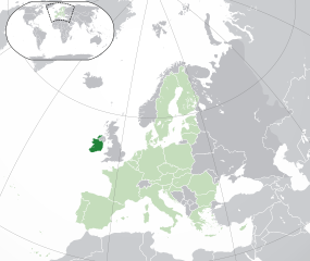
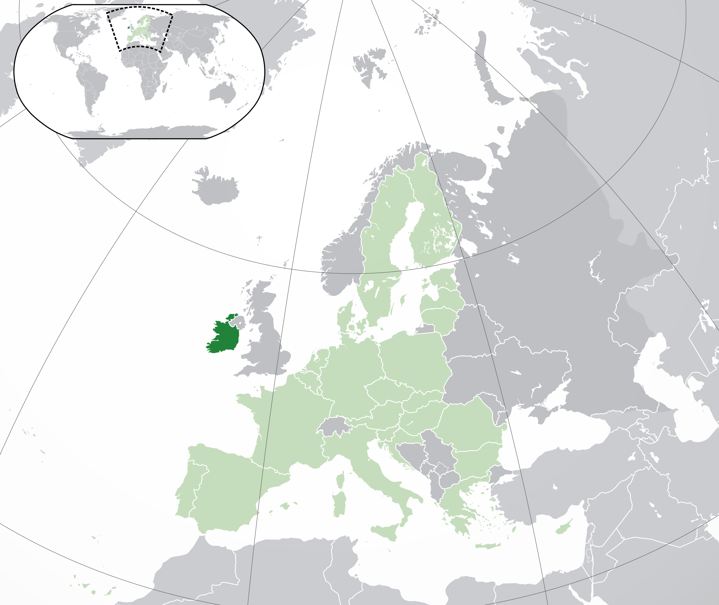
English: (Dark-Green) Republic of Ireland. (Light-Green) The rest of the European Union (EU). (Dark-gray) The rest of Europe. (Light-gray) The surrounding region.
See also: |
| SVG information | Le code de ce grand fichier SVG n'est pas valide en raison de 12 erreurs. |
| Daty | |
| Loharano | |
| Mpamorona azy | NuclearVacuum |
| Versiona hafa |
|


_in_Europe.png)
Moi, en tant que détenteur des droits d’auteur sur cette œuvre, je la publie sous les licences suivantes :
Ity rakita ity dia mitondra ny fahazoan-dalana Creative Commons Attribution-Share Alike 3.0 Unported
- Azonao am-palalahana:
- ny mizara – ny mandika, mizara sy manome ity vokatr'asa ity
- ny mamerina – ny manova ity vokatr'asa ity
- Raha manaraka ireo fepetra ireo :
- mahalala ny namorona azy voalohany – Tsy maintsy manome fampahalalana arifomba momba ny mpamorona ianao, manome rohy manondro ny fahazoan'alalana ary raha nisy fiovana natao. Azonao atao amin'izay fomba rehetra azo atao izany zavatra izany, fa tsy amin'ny fomba milaza hoe manohana na manaiky ny fampiasanao an'ilay asa ilay mpamorona.
- zaraina mitovy – Raha manova, mamadika na mifototra amin'ity asa ity ianao dia tsy maintsy mizara ny vokany amin'ny lisansa mitovy na mifandraika amin'ny lisansan'ny asa niaviana.

|
Nomena ny alalana mandika, mizara ary/na manova ity rakitra ity araka ny GNU Free Documentation License na versiona hafa toariana natontan'i Free Software Foundation; tsy misy fizarana tsy azo ovaina, tsy misy soratra andoham-pejy na soratra am-param-pejy. Ao amin'ny fizarana mitondra anarana GNU Free Documentation License ny soratr'ity fahazoan-dalana ity. |
Afaka mifidy iray amin'ireo lisansa ireo ianao.
| Annotations | Cette image est annotée : Voir les annotations sur Wikimedia Commons |
Tantara ny rakitra
Tsindrio eo amin'ny daty/ora iray mba hijery ny toetra n'ilay rakitra tamin'io fotoana io.
| Daty sy ora | saritapaka | Habe | Mpikambana | resaka | |
|---|---|---|---|---|---|
| ankehitriny | 1 Febroary 2020 à 05:03 | | 2 045 × 1 720 (7,33 Mio) | Rob984 | UK and Gibraltar have left the EU. New base which includes all of Portugal's islands within frame, as well as Arctic Russian islands part of Europe. Also fixed Flevoland in the Netherlands. |
| 25 Oktobra 2016 à 20:31 |  | 2 045 × 1 720 (7,32 Mio) | Giorgi Balakhadze | Rv of sockpuppet and per COM:OVERWRITE | |
| 18 Martsa 2015 à 15:59 |  | 2 045 × 1 720 (7,38 Mio) | Mapclean | Reverted to Leftcry's version, please go to your talk page | |
| 21 Febroary 2015 à 14:07 |  | 2 045 × 1 720 (2,62 Mio) | VS6507 | Spain. Greece. Slovakia. Cyprus. Romania VETO | |
| 16 Novambra 2014 à 19:37 |  | 2 045 × 1 720 (7,38 Mio) | Leftcry | Reverted to version as of 15:40, 6 August 2014 Please go to your talk page | |
| 16 Novambra 2014 à 16:34 |  | 2 045 × 1 720 (2,62 Mio) | A2D2 | The map must show the original de-jure status with no breakaway regions, as it was originally created. An alternative map showing the de-facto status with breakaway regions needs to be created instead. | |
| 16 Novambra 2014 à 15:48 |  | 2 045 × 1 720 (7,38 Mio) | A2D2 | Reverted to version as of 10:27, 13 July 2014 | |
| 6 Aogositra 2014 à 15:40 |  | 2 045 × 1 720 (7,38 Mio) | Rob984 | Sudan | |
| 13 Jolay 2014 à 10:27 |  | 2 045 × 1 720 (7,38 Mio) | Rob984 | More accurate coastline, borders, etc. Slightly different centre point. Added gradient and longitude and latitude lines. Otherwise it's difficult to tell what kind of projection this is and therefore potentially misleading. | |
| 1 Jolay 2013 à 09:14 |  | 2 045 × 1 720 (2,62 Mio) | U5K0 | croatia |
Fampiasana an'io rakitra io
Mampiasa ity rakitra ity io pejy io:
Fampiasan-drakitra maneran-tontolo
Mampiasa ity rakitra ity ireo wiki hafa ireo:
- Fampiasana eo amin'i ady.wikipedia.org
- Fampiasana eo amin'i af.wikipedia.org
- Fampiasana eo amin'i ami.wikipedia.org
- Fampiasana eo amin'i ar.wikipedia.org
- جمهورية أيرلندا
- مستخدم:ElWaliElAlaoui/ملعب 8
- معاملة المثليين في جمهورية أيرلندا
- العلاقات الأنغولية الأيرلندية
- العلاقات الأيرلندية الكورية الجنوبية
- العلاقات الإريترية الأيرلندية
- العلاقات الأيرلندية السويسرية
- العلاقات الألمانية الأيرلندية
- العلاقات الأيرلندية الليختنشتانية
- العلاقات البوليفية الأيرلندية
- العلاقات الأيرلندية الموزمبيقية
- العلاقات الألبانية الأيرلندية
- العلاقات البلجيكية الأيرلندية
- العلاقات الإثيوبية الأيرلندية
- العلاقات الأيرلندية البيلاروسية
- العلاقات الأيرلندية الطاجيكستانية
- العلاقات الأيرلندية الروسية
- العلاقات الأيرلندية الرومانية
- العلاقات الأرجنتينية الأيرلندية
- العلاقات الأيرلندية الغامبية
- العلاقات الأيرلندية القبرصية
- العلاقات الأيرلندية السيراليونية
- العلاقات الأيرلندية النيبالية
- العلاقات الأيرلندية الليبيرية
- العلاقات التشيكية الأيرلندية
- العلاقات الأيرلندية الميانمارية
- العلاقات السعودية الأيرلندية
- العلاقات الأيرلندية الكندية
- العلاقات الأيرلندية الزيمبابوية
- العلاقات الإسرائيلية الأيرلندية
- العلاقات البالاوية الأيرلندية
- العلاقات الأيرلندية المالية
- العلاقات الأيرلندية النيجيرية
- العلاقات اليمنية الأيرلندية
- العلاقات الأيرلندية الفانواتية
- العلاقات الغابونية الأيرلندية
- العلاقات البنمية الأيرلندية
- العلاقات الأيرلندية الكوبية
- العلاقات الأيرلندية الجورجية
- العلاقات التونسية الأيرلندية
- العلاقات الأيرلندية الكورية الشمالية
- العلاقات الهندية الأيرلندية
- العلاقات الإيطالية الأيرلندية
- العلاقات الأيرلندية الناوروية
- العلاقات الأسترالية الأيرلندية
- العلاقات الأيرلندية الزامبية
Hijery fampiasana eran-terikasan'ity rakitra ity.