Sary:Arabian Peninsula dust SeaWiFS-2.jpg

Haben'ny topi-maso: 657 × 600 teboka. Habe hafa: 263 × 240 teboka | 526 × 480 teboka | 841 × 768 teboka | 1 122 × 1 024 teboka | 2 504 × 2 286 teboka
Rakitra niaviana (2 504 × 2 286 teboka, haben'ilay rakitra : 867 kio, endrika MIME : image/jpeg)
| Visavisa |
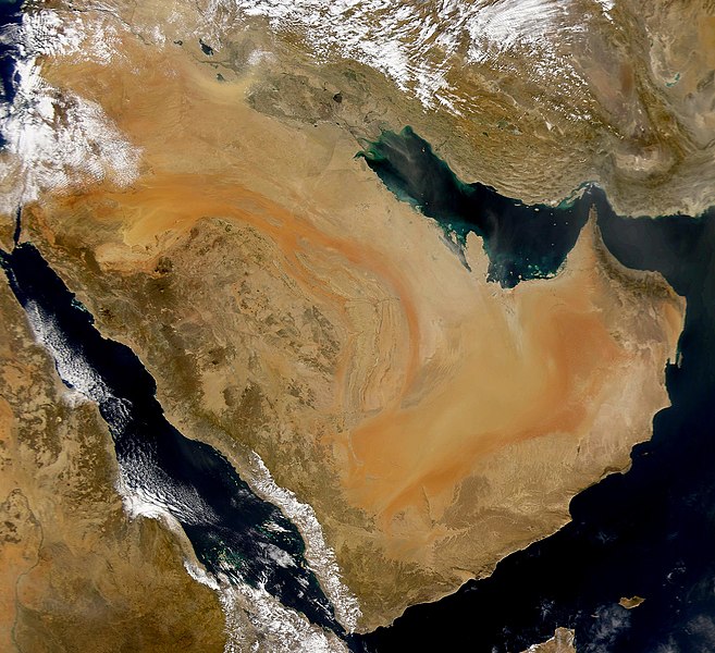
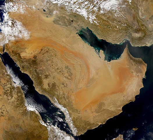
English: SeaWiFS collected this view of the Arabian Peninsula and of dust blowing across the Persian Gulf. Español: La Península Arábiga vista desde el espacio Suomi: Satelliittikuva Arabian niemimaasta
Українська: Компіляція супутникових знімків пилової бурі над Аравійським півостровом, 16 листопада 2008 року. |
| Daty | (UTC) |
| Loharano | |
| Mpamorona azy |
|
| Cette image a été retouchée, ce qui signifie qu'elle a été modifiée par ordinateur et est différente de l'image d'origine. Liste des modifications : Enhanced contrast, midtones. L'image d'origine se trouve ici : Arabian Peninsula dust SeaWiFS.jpg:
|
Moi, en tant que détenteur des droits d’auteur sur cette œuvre, je la publie sous la licence suivante :
| This image is from the Sea-viewing Wide Field-of-view Sensor (SeaWiFS) Project and more than 5 years old.
Satellite data captured by the SeaWIFS sensor are released into the public domain 5 years after capture. Data less than five years old can be re-used only for educational or scientific purposes; any commercial use of such images must be coordinated with GeoEye. [1] |
| This work has been released into the public domain by its copyright holder, GeoEye. This applies worldwide. Dans certains pays, ceci peut ne pas être possible ; dans ce cas : GeoEye accorde à toute personne le droit d’utiliser cette œuvre dans n’importe quel but, sans aucune condition, sauf celles requises par la loi.
|
Laogin'ny fampidirana loharano
This image is a derivative work of the following images:
- Image:Arabian_Peninsula_dust_SeaWiFS.jpg licensed with PD-SeaWiFS
- 2008-01-02T17:02:18Z Hautala 2504x2286 (873404 Bytes) {{PD-USGov-NASA}} * {{en|Satellite image of Arabian peninsula}} * {{es|La Península Arábiga vista desde el espacio}} * {{en|Satelliittikuva Arabian niemimaasta}} Taken from NASA's [http://visibleearth.nasa.gov/ Visible E
Téléversé avec derivativeFX
Tantara ny rakitra
Tsindrio eo amin'ny daty/ora iray mba hijery ny toetra n'ilay rakitra tamin'io fotoana io.
| Daty sy ora | saritapaka | Habe | Mpikambana | resaka | |
|---|---|---|---|---|---|
| ankehitriny | 16 Novambra 2008 à 04:59 | | 2 504 × 2 286 (867 kio) | John Nevard | {{Information |Description={{en|SeaWiFS collected this view of the Arabian Peninsula and of dust blowing across the Persian Gulf.}} {{es|La Península Arábiga vista desde el espacio}} {{en|Satelliittikuva Arabian niemimaasta}} |Source=*[[:Image:Arabian_P |
Fampiasana an'io rakitra io
Mampiasa ity rakitra ity io pejy io:
Fampiasan-drakitra maneran-tontolo
Mampiasa ity rakitra ity ireo wiki hafa ireo:
- Fampiasana eo amin'i af.wikipedia.org
- Fampiasana eo amin'i ang.wikipedia.org
- Fampiasana eo amin'i ar.wikipedia.org
- Fampiasana eo amin'i ar.wikiquote.org
- Fampiasana eo amin'i arz.wikipedia.org
- Fampiasana eo amin'i awa.wikipedia.org
- Fampiasana eo amin'i azb.wikipedia.org
- Fampiasana eo amin'i az.wikipedia.org
- Fampiasana eo amin'i bcl.wikipedia.org
- Fampiasana eo amin'i bh.wikipedia.org
- Fampiasana eo amin'i bn.wikipedia.org
- Fampiasana eo amin'i ckb.wikipedia.org
- Fampiasana eo amin'i da.wikipedia.org
- Fampiasana eo amin'i el.wikipedia.org
- Fampiasana eo amin'i en.wikipedia.org
- Fampiasana eo amin'i en.wikibooks.org
- Fampiasana eo amin'i eo.wikipedia.org
- Fampiasana eo amin'i es.wikipedia.org
- Fampiasana eo amin'i fr.wikibooks.org
- Fampiasana eo amin'i ja.wikipedia.org
- Fampiasana eo amin'i kab.wikipedia.org
- Fampiasana eo amin'i ka.wikipedia.org
- Fampiasana eo amin'i ko.wikipedia.org
- Fampiasana eo amin'i lb.wikipedia.org
- Fampiasana eo amin'i mr.wikipedia.org
- Fampiasana eo amin'i ms.wikipedia.org
- Fampiasana eo amin'i nn.wikipedia.org
Hijery fampiasana eran-terikasan'ity rakitra ity.