Sary:AchaemenidMapBehistunInscription.png

Haben'ny topi-maso: 800 × 511 teboka. Habe hafa: 320 × 205 teboka | 640 × 409 teboka | 1 020 × 652 teboka
Rakitra niaviana (1 020 × 652 teboka, haben'ilay rakitra : 17 kio, endrika MIME : image/png)
Ambangovangony
| Visavisa |
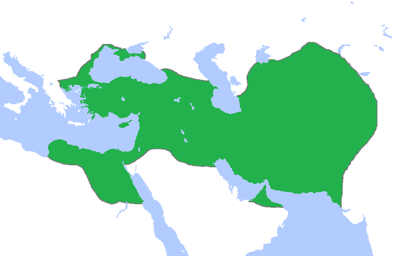
English: This a map of the Achaemenid Empire showing its greatest extent. I have given it more regions as listed on the Behistun Inscription the Persian King Darius wrote telling his conquests. |
| Daty | |
| Loharano | http://en.wikipedia.org/wiki/File:Achemenids500BC.png |
| Mpamorona azy | Gabagool |
| Alalana (Hampiasa ity rakitra ity indray) |
http://en.wikipedia.org/wiki/File:Achemenids500BC.png |
- Other information
English: This is a map I have edited from that map and it says that I am free to share, to remix, but under the following conditions that i must the work in the manner specified by the author or licensor.
Azo alaina araka ny lisansa licence Creative Commons Attribution 1.0 Generic ity rakitra ity
- Azonao am-palalahana:
- ny mizara – ny mandika, mizara sy manome ity vokatr'asa ity
- ny mamerina – ny manova ity vokatr'asa ity
- Raha manaraka ireo fepetra ireo :
- mahalala ny namorona azy voalohany – Tsy maintsy manome fampahalalana arifomba momba ny mpamorona ianao, manome rohy manondro ny fahazoan'alalana ary raha nisy fiovana natao. Azonao atao amin'izay fomba rehetra azo atao izany zavatra izany, fa tsy amin'ny fomba milaza hoe manohana na manaiky ny fampiasanao an'ilay asa ilay mpamorona.
Ce fichier est disponible selon les termes de la licence Creative Commons Attribution 3.0 Non transposée.
- Azonao am-palalahana:
- ny mizara – ny mandika, mizara sy manome ity vokatr'asa ity
- ny mamerina – ny manova ity vokatr'asa ity
- Raha manaraka ireo fepetra ireo :
- mahalala ny namorona azy voalohany – Tsy maintsy manome fampahalalana arifomba momba ny mpamorona ianao, manome rohy manondro ny fahazoan'alalana ary raha nisy fiovana natao. Azonao atao amin'izay fomba rehetra azo atao izany zavatra izany, fa tsy amin'ny fomba milaza hoe manohana na manaiky ny fampiasanao an'ilay asa ilay mpamorona.
Tantara ny rakitra
Tsindrio eo amin'ny daty/ora iray mba hijery ny toetra n'ilay rakitra tamin'io fotoana io.
| Daty sy ora | saritapaka | Habe | Mpikambana | resaka | |
|---|---|---|---|---|---|
| ankehitriny | 23 Oktobra 2015 à 00:53 | | 1 020 × 652 (17 kio) | LouisAragon | blocked sock. |
| 13 Oktobra 2015 à 02:01 |  | 1 020 × 652 (22 kio) | History of Persia | My apologies sir but they did conquer parts of arabia. See the Achaemenid Arabia article. | |
| 13 Oktobra 2015 à 01:50 |  | 1 020 × 652 (17 kio) | LouisAragon | Reverted to version as of 22:39, 6 February 2015 (UTC) | |
| 13 Oktobra 2015 à 01:24 |  | 1 020 × 652 (22 kio) | LouisAragon | correct. | |
| 13 Oktobra 2015 à 01:21 |  | 1 020 × 652 (22 kio) | LouisAragon | They simply did not conquer those territories you just added on all sides. | |
| 8 Septambra 2015 à 23:28 |  | 1 012 × 648 (19 kio) | History of Persia | More accurate map. info on greek territories: File:Map Greco-Persian Wars-en.svg, size of Mascat (modern Oman/UAE): File:East-Hem 600bc.jpg. clay tablets in old persian have been found in bahrain, so its likely they were part of the achaemenid empire,... | |
| 29 Jolay 2015 à 00:48 |  | 1 020 × 652 (20 kio) | History of Persia | made achaemenid arabia better | |
| 9 Jolay 2015 à 00:25 |  | 1 020 × 652 (22 kio) | History of Persia | They had also conquered arabia-petrea (though it did not exist with that name) A wikipedia article of the province exists: Achaemenid Arabia | |
| 6 Febroary 2015 à 22:39 |  | 1 020 × 652 (17 kio) | HistoryofIran | I aprreciete your effort, but could you please upload the picture instead of replacing it with mine? thanks. | |
| 29 Janoary 2015 à 04:55 |  | 1 020 × 652 (59 kio) | Javierfv1212 | Updated the map by delineating the conquests of the three major Persian conqueror Kings, and also adding the names of the main satrapies of the empire. As a source I used this map of Ian Mladjov's Resources from the University of Michigan's History dep... |
Fampiasana an'io rakitra io
Mampiasa ity rakitra ity io pejy io:
Fampiasan-drakitra maneran-tontolo
Mampiasa ity rakitra ity ireo wiki hafa ireo:
- Fampiasana eo amin'i ar.wikipedia.org
- Fampiasana eo amin'i be.wikipedia.org
- Fampiasana eo amin'i da.wikipedia.org
- Fampiasana eo amin'i en.wikipedia.org
- Fampiasana eo amin'i en.wikivoyage.org
- Fampiasana eo amin'i eo.wikipedia.org
- Fampiasana eo amin'i es.wikipedia.org
- Fampiasana eo amin'i fa.wikipedia.org
- Fampiasana eo amin'i fr.wikipedia.org
- Fampiasana eo amin'i gl.wikipedia.org
- Fampiasana eo amin'i hu.wikipedia.org
- Fampiasana eo amin'i hy.wikipedia.org
- Fampiasana eo amin'i id.wikibooks.org
- Fampiasana eo amin'i incubator.wikimedia.org
- Fampiasana eo amin'i it.wikipedia.org
- Fampiasana eo amin'i it.wikiversity.org
- Fampiasana eo amin'i ja.wikipedia.org
- Fampiasana eo amin'i la.wikipedia.org
- Fampiasana eo amin'i li.wikipedia.org
- Fampiasana eo amin'i ms.wikipedia.org
- Fampiasana eo amin'i no.wikipedia.org
- Fampiasana eo amin'i pl.wikipedia.org
- Fampiasana eo amin'i pnb.wikipedia.org
- Fampiasana eo amin'i ps.wikipedia.org
- Fampiasana eo amin'i ru.wikipedia.org
- Fampiasana eo amin'i simple.wikipedia.org
- Fampiasana eo amin'i sr.wikipedia.org
- Fampiasana eo amin'i te.wikipedia.org
- Fampiasana eo amin'i th.wikipedia.org
- Fampiasana eo amin'i tr.wikipedia.org
- Fampiasana eo amin'i tt.wikipedia.org
Hijery fampiasana eran-terikasan'ity rakitra ity.