Sary:Troas.png
Troas.png (520 × 539 teboka, haben'ilay rakitra : 113 kio, endrika MIME : image/png)
Ambangovangony
| Visavisa |
Deutsch: Landkarte der Troas
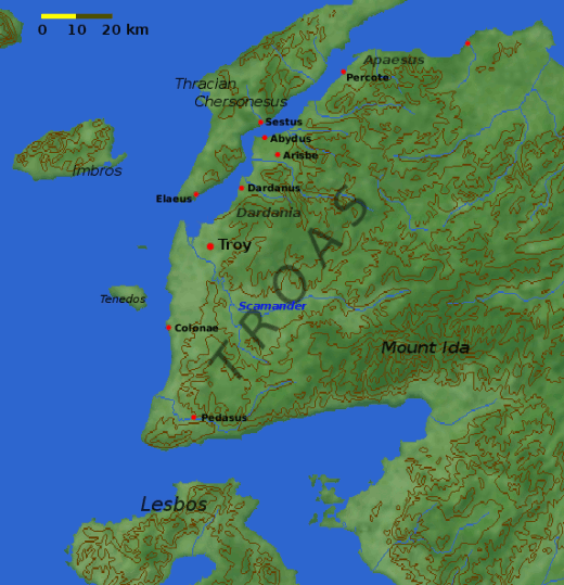
English: Map of the Troad, including the site of Troy. Note that the modern coastline has been altered to show a bay at the mouth of Scamander where the Greek ships would have been.
Nederlands: ligging en omgeving van Troje |
| Daty | 4 Desambra 2004 (date de téléversement originale) |
| Loharano | Transferred from en.wikipedia to Commons. |
| Mpamorona azy |
Dbachmann sur Wikipedia Anglisy Later versions were uploaded by Joy at en.wikipedia. |
| Versiona hafa |
Derivative works of this file: Ancient edremit gulf.jpg
|


|
Une version vectorielle de cette image existe, dans le format « SVG ». Elle devrait être utilisée à la place de cette image matricielle.
File:Troas.png → File:Troas.svg
Pour plus d’informations sur les images vectorielles, consultez la page de transition de Commons vers le format SVG. Voir aussi les informations à propos de la manière dont le logiciel MediaWiki gère les images au format SVG. |
 |
Navoaka tambanin'ny lisansy

|
Nomena ny alalana mandika, mizara ary/na manova ity rakitra ity araka ny GNU Free Documentation License na versiona hafa toariana natontan'i Free Software Foundation; tsy misy fizarana tsy azo ovaina, tsy misy soratra andoham-pejy na soratra am-param-pejy. Ao amin'ny fizarana mitondra anarana GNU Free Documentation License ny soratr'ity fahazoan-dalana ity. |
| Ity rakita ity dia mitondra ny fahazoan-dalana Creative Commons Attribution-Share Alike 3.0 Unported | ||
| ||
| Ce bandeau de licence a été ajouté à ce fichier dans le cadre de la procédure de mise à jour des licences des images sous GFDL. |
|
NOTE: "subject to disclaimers" below may not actually apply, this was tagged with {{GFDL-user-en}}, and after May 2007, en:Template:GFDL-self did not require disclaimers. Please check the image description page on the English Wikipedia (or, if it has been deleted, ask an English Wikipedia administrator). See Wikipedia:GFDL standardization for details. | ||
Joy de en.wikipedia.org, en tant que détenteur des droits d’auteur sur cette œuvre, la publie sous la licence suivante :
| ||
|
Note: This tag should not be used. For images that were released on the English Wikipedia using either GFDL or GFDL-self with disclaimers, use {{GFDL-user-en-with-disclaimers}}. For images without disclaimers please use {{GFDL-user-en-no-disclaimers}} instead. If you are the copyright holder of files that were released on Wikipedia, please consider removing the disclaimers. |
Laogin'ny fampidirana loharano
- 2005-03-06 14:15 Joy 520×539×8 (115389 bytes) reduced palette to 256 colors to halve the file size with negligible visual impact (reducing to 150 colors drops some 15KB more but it's not worth it)
- 2004-12-15 13:50 Dbachmann 520×539×8 (286334 bytes) scale
- 2004-12-04 15:03 Dbachmann 447×475×8 (193411 bytes) update position of Troy
- 2004-12-04 13:34 Dbachmann 450×489×8 (203976 bytes) '
- 2004-12-04 12:43 Dbachmann 470×519×8 (228694 bytes) {{GFDL}}
Tantara ny rakitra
Tsindrio eo amin'ny daty/ora iray mba hijery ny toetra n'ilay rakitra tamin'io fotoana io.
| Daty sy ora | saritapaka | Habe | Mpikambana | resaka | |
|---|---|---|---|---|---|
| ankehitriny | 11 Janoary 2006 à 05:37 | | 520 × 539 (113 kio) | Olliminatore | from en: |
Fampiasana an'io rakitra io
Mampiasa ity rakitra ity io pejy io:
Fampiasan-drakitra maneran-tontolo
Mampiasa ity rakitra ity ireo wiki hafa ireo:
- Fampiasana eo amin'i af.wikipedia.org
- Fampiasana eo amin'i am.wikipedia.org
- Fampiasana eo amin'i ar.wikipedia.org
- Fampiasana eo amin'i arz.wikipedia.org
- Fampiasana eo amin'i azb.wikipedia.org
- Fampiasana eo amin'i az.wikipedia.org
- Fampiasana eo amin'i ba.wikipedia.org
- Fampiasana eo amin'i be.wikipedia.org
- Fampiasana eo amin'i bg.wikipedia.org
- Fampiasana eo amin'i bn.wikipedia.org
- Fampiasana eo amin'i br.wikipedia.org
- Fampiasana eo amin'i ceb.wikipedia.org
- Fampiasana eo amin'i ce.wikipedia.org
- Fampiasana eo amin'i cs.wikipedia.org
- Fampiasana eo amin'i cy.wikipedia.org
- Fampiasana eo amin'i de.wikipedia.org
- Fampiasana eo amin'i el.wikipedia.org
- Fampiasana eo amin'i en.wikipedia.org
- Fampiasana eo amin'i es.wikipedia.org
- Fampiasana eo amin'i eu.wikipedia.org
- Fampiasana eo amin'i fi.wikipedia.org
- Fampiasana eo amin'i fr.wikipedia.org
- Fampiasana eo amin'i fy.wikipedia.org
- Fampiasana eo amin'i he.wikipedia.org
- Fampiasana eo amin'i hr.wikipedia.org
- Fampiasana eo amin'i hu.wikipedia.org
Hijery fampiasana eran-terikasan'ity rakitra ity.