Sary:Noord-Holland position.svg

Taille de cet aperçu PNG pour ce fichier SVG : 200 × 236 teboka. Habe hafa: 203 × 240 teboka | 407 × 480 teboka | 651 × 768 teboka | 868 × 1 024 teboka | 1 736 × 2 048 teboka
Rakitra niaviana (rakitra SVG, habe 200 × 236 teboka, habe : 158 kio)
Ambangovangony
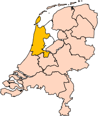
| Visavisa | Location of the province of Noord-Holland (North Holland) in the Netherlands. |
| Daty | |
| Loharano | Own work, based on freely available GIS data |
| Mpamorona azy | User:Mtcv |
| Alalana (Hampiasa ity rakitra ity indray) |
Data: attribution required; my work: PD |
| Versiona hafa | I attempted to make an svg version of Image:Noord Holland-Position.png (with less simplified boundaries) |
Clickable version


|
Ambaran'i Centraal Bureau voor de Statistiek, mpitazon'ny zom-pamoron'ity rakitra ity, fa azon'ny rehetra ampiasaina ho an'ny fampiasana rehetra ity rakitra ity, raha fantatra na voatono tsara ny mpamoron'ity vokatr'asa ity. Ny fampizarazarana, ny vokatr'asa avy aminy, ny fivarotana azy ary ny fampiasana hafa rehetra dia azo atao. |
Fampatsiahivana:
|
| Annotations | This image is annotated: View the annotations at Commons |


Tantara ny rakitra
Tsindrio eo amin'ny daty/ora iray mba hijery ny toetra n'ilay rakitra tamin'io fotoana io.
| Daty sy ora | saritapaka | Habe | Mpikambana | resaka | |
|---|---|---|---|---|---|
| ankehitriny | 2 Martsa 2019 à 17:20 | | 200 × 236 (158 kio) | Thayts | update |
| 2 Oktobra 2006 à 15:13 |  | 200 × 236 (158 kio) | Mtcv | {{Information| |Description=Location of the province of Noord-Holland (North Holland) in the Netherlands. |Source=Own work, based on freely available GIS data |Date=2006-10-02 |Author=User:Mtcv |Permission=Data: attribution required; my work: PD |othe |
Fampiasana an'io rakitra io
Tsy misy pejy mampiasa an'ity rakitra ity.
Fampiasan-drakitra maneran-tontolo
Mampiasa ity rakitra ity ireo wiki hafa ireo:
- Fampiasana eo amin'i ar.wikipedia.org
- أمستردام
- شمال-هولندا
- هلفرسوم
- ألكمار
- هارلم (شمال-هولندا)
- زانستاد
- هارلمرمير
- قالب:بلديات شمال هولندا
- سخاخن
- دن هيلدر
- فيلسن
- زانتفورت
- بلوميندال
- ألسمير
- لاندسمير
- أوستزان
- تيسل
- أمستلفين
- إنكهاوزن
- هورن (هولندا)
- فاترلاند
- بيمستر
- بيفيرفايك
- بيرخن (شمال هولندا)
- بلاريكوم
- هيمستيده
- بوابة:أمستردام/قوالب
- بوابة:أمستردام
- حكومة أمستردام
- هارلمرليده آن سبارنفاودا
- آودر- أمستل
- ديمين
- فيسب (هولندا)
- كاستركوم
- دريخترلاند
- إدام- فولندام
- هيمسكيرك
- هيرهوخوفارد
- هيلو (هولندا)
- هولاندز كرون
- هاوزن
- كوخينلاند
- لانجادايك
- لارين (هولندا)
- ميديمبليك
- أوبمير
- بورميراند
- ستيده بروك
- آوتخيست
- آوتهورن
Hijery fampiasana eran-terikasan'ity rakitra ity.