Sary:Egypt NK edit.svg

Taille de cet aperçu PNG pour ce fichier SVG : 512 × 599 teboka. Habe hafa: 205 × 240 teboka | 410 × 480 teboka | 656 × 768 teboka | 875 × 1 024 teboka | 1 749 × 2 048 teboka | 1 282 × 1 501 teboka
Rakitra niaviana (rakitra SVG, habe 1 282 × 1 501 teboka, habe : 252 kio)
Ambangovangony
| Visavisa |
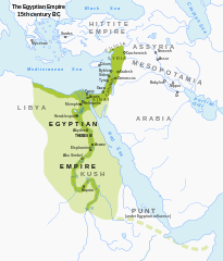
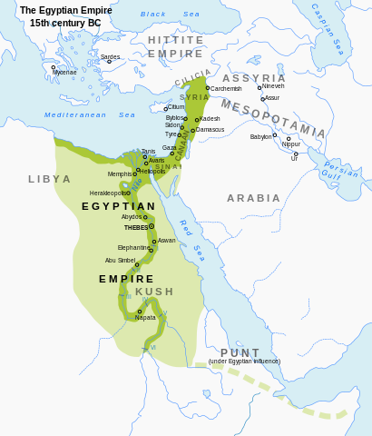
English: Map of Egypt's territorial control during the New Kingdom. Modified from en:Image:Egypt_1450_BC.svg; includes a more muted color scheme. |
| Daty | (UTC) |
| Loharano | Travail personnel basé sur : Egypt 1450 BC.svg |
| Mpamorona azy | ArdadN, Jeff Dahl |
| Versiona hafa |
[]
|


|
This SVG file contains embedded text that can be translated into your language, using any capable SVG editor, text editor or the SVG Translate tool. For more information see: About translating SVG files. |
Moi, en tant que détenteur des droits d’auteur sur cette œuvre, je la publie sous les licences suivantes :
Ity rakita ity dia mitondra ny fahazoan-dalana Creative Commons Attribution-Share Alike 3.0 Unported
- Azonao am-palalahana:
- ny mizara – ny mandika, mizara sy manome ity vokatr'asa ity
- ny mamerina – ny manova ity vokatr'asa ity
- Raha manaraka ireo fepetra ireo :
- mahalala ny namorona azy voalohany – Tsy maintsy manome fampahalalana arifomba momba ny mpamorona ianao, manome rohy manondro ny fahazoan'alalana ary raha nisy fiovana natao. Azonao atao amin'izay fomba rehetra azo atao izany zavatra izany, fa tsy amin'ny fomba milaza hoe manohana na manaiky ny fampiasanao an'ilay asa ilay mpamorona.
- zaraina mitovy – Raha manova, mamadika na mifototra amin'ity asa ity ianao dia tsy maintsy mizara ny vokany amin'ny lisansa mitovy na mifandraika amin'ny lisansan'ny asa niaviana.

|
Nomena ny alalana mandika, mizara ary/na manova ity rakitra ity araka ny GNU Free Documentation License na versiona hafa toariana natontan'i Free Software Foundation; tsy misy fizarana tsy azo ovaina, tsy misy soratra andoham-pejy na soratra am-param-pejy. Ao amin'ny fizarana mitondra anarana GNU Free Documentation License ny soratr'ity fahazoan-dalana ity. |
Afaka mifidy iray amin'ireo lisansa ireo ianao.
Tantara ny rakitra
Tsindrio eo amin'ny daty/ora iray mba hijery ny toetra n'ilay rakitra tamin'io fotoana io.
| Daty sy ora | saritapaka | Habe | Mpikambana | resaka | |
|---|---|---|---|---|---|
| ankehitriny | 23 Septambra 2023 à 22:56 | | 1 282 × 1 501 (252 kio) | Gaaryeelidmaan | Punt was associated with Myrrh trade, a product found in tip of the Horn https://www.worldhistory.org/punt/ |
| 16 Oktobra 2013 à 17:27 |  | 1 282 × 1 501 (252 kio) | Rowanwindwhistler | Reverted to version as of 02:05, 7 July 2008, uploaded by mistake. | |
| 16 Oktobra 2013 à 17:24 |  | 1 282 × 1 501 (251 kio) | Rowanwindwhistler | Some labels corrected, square background added to map title. | |
| 7 Jolay 2008 à 02:05 |  | 1 282 × 1 501 (252 kio) | Jeff Dahl | {{Information |Description={{en|1=Map of Egypt's territorial control during the New Kingdom. Modified from Image:Egypt_1450_BC.svg; includes a more muted color scheme.}} |Source=Modified from Image:Egypt_1450_BC.svg by User:Andrei Nacu, modi |
Fampiasana an'io rakitra io
Mampiasa ity rakitra ity ireo pejy 2 ireo:
Fampiasan-drakitra maneran-tontolo
Mampiasa ity rakitra ity ireo wiki hafa ireo:
- Fampiasana eo amin'i anp.wikipedia.org
- Fampiasana eo amin'i ar.wikipedia.org
- Fampiasana eo amin'i azb.wikipedia.org
- Fampiasana eo amin'i ba.wikipedia.org
- Fampiasana eo amin'i be-tarask.wikipedia.org
- Fampiasana eo amin'i bg.wikipedia.org
- Fampiasana eo amin'i bxr.wikipedia.org
- Fampiasana eo amin'i de.wikipedia.org
- Fampiasana eo amin'i en.wikipedia.org
- Fampiasana eo amin'i eu.wikipedia.org
- Fampiasana eo amin'i fa.wikipedia.org
- Fampiasana eo amin'i gu.wikipedia.org
- Fampiasana eo amin'i he.wikipedia.org
- Fampiasana eo amin'i hi.wikipedia.org
- Fampiasana eo amin'i hy.wikipedia.org
- Fampiasana eo amin'i id.wikipedia.org
- Fampiasana eo amin'i incubator.wikimedia.org
- Fampiasana eo amin'i ja.wikipedia.org
- Fampiasana eo amin'i ka.wikipedia.org
- Fampiasana eo amin'i kn.wikipedia.org
- Fampiasana eo amin'i ko.wikipedia.org
- Fampiasana eo amin'i ml.wikipedia.org
- Fampiasana eo amin'i mt.wikipedia.org
- Fampiasana eo amin'i pnb.wikipedia.org
- Fampiasana eo amin'i ru.wikipedia.org
- Fampiasana eo amin'i sl.wikipedia.org
- Fampiasana eo amin'i sq.wikipedia.org
- Fampiasana eo amin'i sv.wikipedia.org
- Fampiasana eo amin'i sw.wikipedia.org
- Fampiasana eo amin'i th.wikipedia.org
- Fampiasana eo amin'i tl.wikipedia.org
- Fampiasana eo amin'i uk.wikipedia.org
- Fampiasana eo amin'i ur.wikipedia.org
- Fampiasana eo amin'i vep.wikipedia.org
- Fampiasana eo amin'i xmf.wikipedia.org
- Fampiasana eo amin'i zh.wikipedia.org